How Many Trips Are ‘Captured’ By More Diverse Urban Land Use?
Current methods of predicting the traffic-calming effects of mixed-use development are “woefully lacking” and risk underestimating the transportation benefits of more compact, diverse land use, according to a new report from the Transportation Research Board (TRB).
 An example of mixed-use development in San Francisco. (Photo: Arch. Record)
The TRB report is the first to examine mixed-use development on a nationwide level, looking initially at six metro areas and poised to add data from seven more in the coming months.
It focuses on “internal capture,” the traffic analyst’s term to describe how many auto trips are effectively removed — that is, “captured” — from the street network.
“Except for a handful of master-planned projects in Florida, actual numbers on internal capture rates [for mixed-use development] are few and far between,” the TRB researchers wrote. “Traffic engineers are thus largely left to their own devices to quantify the trip reductions that might accrue from this often varied and complex development type. Oftentimes, no adjustment is made.”
So how many trips are actually removed from congested streets by more diverse land use? Three out of every 10 on average, the TRB researchers found.
Every captured trip serves to decrease the strain on existing roads and reduce the carbon footprint of the community as a whole. Increasing the effectiveness of mixed-use projects isn’t as simple as offering a broad mix of housing, however. A number of variables help to determine how much automobile dependence can be mitigated, according to the TRB:
- The site’s total population and employment
- The site’s density
- The size of households living on the site, and their car ownership rates
- The availability of walkable employment
- The site’s pedestrian accessibility, e.g. sidewalk use
- The accessibility of transit, as well as employment within a 30-minute transit ride
The new report serves as a complement of sorts to the TRB’s broader study of land use’s effect on greenhouse gas emissions, which Ryan covered last week. But it also speaks to the power of data collection to improve policy-making on the national as well as local level — as TRB’s researchers noted, the lack of sufficient information had impeded planners’ understanding of mixed-use development.
Seen in that light, the Obama administration’s proposal to add $310 million for regional data collection to the upcoming federal transportation bill begins to appear less like a small-bore reform. Still, even that provision could be jettisoned as lawmakers negotiate an extension of existing transport law.
(h/t Reconnecting America)

Streetsblog has migrated to a new comment system. New commenters can register directly in the comments section of any article. Returning commenters: your previous comments and display name have been preserved, but you'll need to reclaim your account by clicking "Forgot your password?" on the sign-in form, entering your email, and following the verification link to set a new password — this is required because passwords could not be carried over during the migration. For questions, contact tips@streetsblog.org.
More from Streetsblog USA
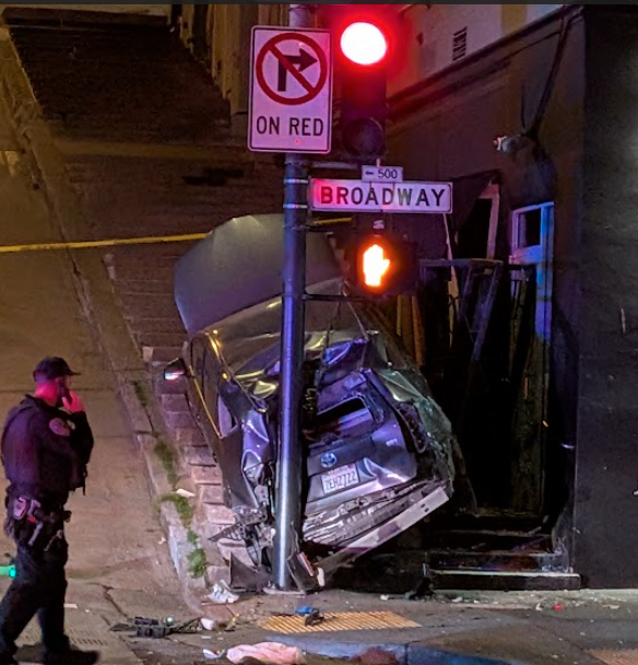
Motorist Careens onto North Beach Sidewalk, Killing Pedestrian
Driver kills pedestrian at another location where a safety project festered
The post Motorist Careens onto North Beach Sidewalk, Killing Pedestrian appeared first on Streetsblog San Francisco.