Maps
Transit App Now Provides Safety-First Bike Directions
A commuter train, subway and bus app is launching an update to allow users to prioritize safe bike routes.
September 12, 2024

How Sustainable is Your City’s Transportation Network?
...and how does it compare with its peer communities?
May 29, 2024

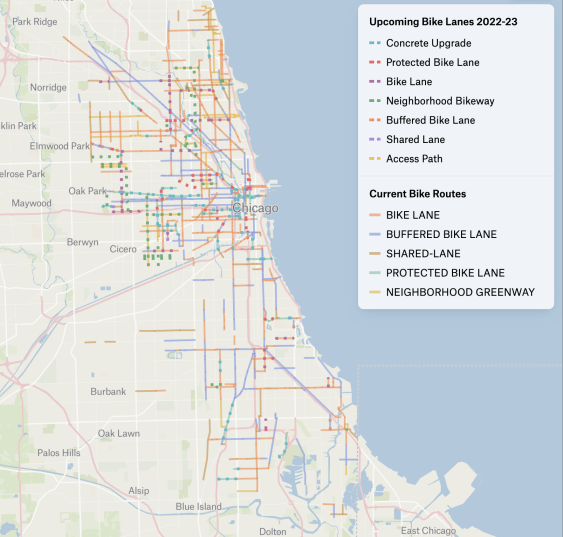
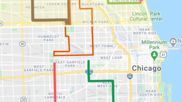
Check Out This Neat Map of Chicago’s Upcoming Bike Lanes
Chi Hack Night volunteer Sean MacMullan geocoded Chicago Department of Transportation bike network data and created the nifty map.
July 11, 2023
New Tool Maps Sidewalks From the Sky — And Encourages Cities to Fill The Gaps
Cities across America will soon be able to easily map their pedestrian infrastructure using the power of artificial intelligence — and challenge them to have a long overdue conversation about why those networks have such an acceptable number of gaps. Now there are no excuses.
March 27, 2023

Here’s the colorful story of how CTA ‘L’ lines got their hues
While it seems like the CTA's lines have been designated with colors forever, it's actually only been that way for a few decades.
March 2, 2023

Could a network of Slow Streets circuits speed pandemic recovery?

January 27, 2021
The Consequences of Political Foot-Dragging
The Senate Environment and Public Works Committee is meeting tomorrow to discuss a four-month extension to the current transportation bill, SAFETEA-LU. The map above is from a short but powerful document the Federal Transit Administration put out this week explaining "The Impacts of Failing to Extend Surface Transportation Funding" [PDF]. How much transit work would grind to a halt in your state without an extension?
September 7, 2011